
1.9 What is Remote Sensing?
Written By Ali Naeini, Ali Abkar, and Nanno Mulder
Remote Sensing Definition
There are many possible definitions about what Remote Sensing (abbreviated as RS) actually is.
Here's a collection of quotes:
F.F. Sabins (1999) in his book "Remote sensing: principles and interpretation" defines it as follows:
"Remote Sensing is the science of acquiring, processing and interpreting images that record the interaction between electromagnetic energy and matter."
The United Nations in their annex Principles Relating to Remote Sensing of the Earth from Space defines it as: (this definition is part of the General Assembly Resolutions and International Treaties Pertaining to the Peaceful Uses of Outer Space):
"The term Remote Sensing means the sensing of the Earth's surface from space by making use of the properties of electromagnetic waves emitted, reflected or diffracted by the sensed objects, for the purpose of improving natural resources management, land use and the protection of the environment."
Lillesand and Kiefer (2000) in their book "Remote Sensing and Image Interpretation" even define it as an art:
"Remote Sensing is the science and art of obtaining information about an object, area, or phenomenon through the analysis of data acquired by a device that is not in contact with the object, area, or phenomenon under investigation."
Probably the broadest definition is given by Charles Elachi (1999) in "Introduction to the Physics and Techniques of Remote Sensing":
"Remote Sensing is defined as the acquisition of information about an object without being in physical contact with it."
European Space Agency (ESA) defines remote sensing as (https://www.esa.int/SPECIALS/Eduspace_EN/SEMF9R3Z2OF_0.html):
A way of collecting and analysing data to get information about an object without the instrument used to collect the data being in direct contact with the object, for example, if you take a photograph of your house, and on the picture you see that the house is composed of a roof, walls and windows, all of which appear as different colors, then this is remote sensing. In remote sensing, three elements are essential. They are:
1 - a Platform to hold the instrument
2 -a Payload or a sensor to observe the target
3- a Target object to be observed
For example, when you take a photograph of your house, you are the platform, the photographic emulsion of the film inside the camera is the sensor and the house is the target object. A key additional element, and the main purpose of remote sensing systems, is:
4 - The Information that is obtained from the acquired data, and how it is used and stored, in the example of the photograph of your house, the information obtained is all you can identify about the house from the photograph. Examples could be the color of the shutters, a hole in the roof, and an open window.
Therefore, Remote Sensing is a technique for measuring objects and processes in the environment for the purpose of understanding and managing the Earth's resources and environment without direct physical contact between the measurement device (from aircraft, spacecraft, ships, drones, photographic cameras, or video cameras) and the object (Earth surface). Interpretation and analysis of the data acquired by remote sensing techniques is commonly regarded as an integral part of remote sensing. Remote sensing, as such, includes both data acquisition and data interpretation [Mulder 1986]. Sometimes there is good-natured debate on how far an object must be from the measuring device before it can be considered “remote”, but this is merely a semantic issue; as long as it is a non-contact sensing we call it remote sensing.
Modelling the RS system
The following figures introduce an overall representation of an RS system , which shows the relationships among the four major components of the system: the atmospheric path, the scene (Earth surface), the sensor, and the image analysis [Swain and Davis 1978, Strahler et al. 1986]. The data acquisition is modeled by its three main parts: the atmosphere, the scene, and the sensor, each represented by a model. Graetz 1990 called the combination of three models, RS model. Optimal information extraction can proceed only by the derivation and use of these models to account for the transformations that take place at each of these parts [Strahler et al. 1986].

A remote sensor measures reflected or emitted energy. An active sensor has its own source of energy (ITC textbook of Principles of RS, 2009)

The schematic diagram for the remote sensing system (e.g., for reflected part of energy) and its two major components, the RS data acquisition part and the RS data analysis part.
Optical Remote Sensing Satellites
Over the past 50 years, the most widely used optical remote sensing systems were LANDSAT, SPOT and NOAA satellites. New remote sensing satellites carrying optical sensors have been launched recently by a number of national and European space agencies and private companies. Examples are the Chinese-Brazilian remote sensing system, the US Landsat 9 and TERRA spacecraft, the Indian IRS series and several Japanese, Russian experimental projects, and Sentinel from the European Space Agency. The first private remote sensing satellite, IKONOS, was launched in 1998.
Data Resolution and Extent
Resolution refers to the intensity or rate sampling, and extent refers to the overall coverage of a dataset. Extend can be seen as relating to the largest feature, or range of features, which can be observed, while resolution relates to the smallest. For a feature to be distinguishable in the data, the resolution and extent of the measurement dimensions of the dataset need to be appropriate to the measurable properties of the feature. For a feature to be separable from other features, these measurements must also be able to discriminate between the differences in reflectance from the features.
Resolution and extend can be seen to operate in four dimensions of remotely sensed data acquisition:
Spectral resolution relates to the width of wavelength channels, extent describes the number and spectral range of channels in the image.
Spatial resolution relates to the pixel size, extend to the overall image coverage
Radiometric resolution relates to the energy difference which determines different radiation levels in an image, extent to the number of levels detected.
Temporal resolution relates to the repeat cycle or interval between successive acquisitions, extent to the total period over which imagery is available [Harrison, 1998].
Remote Sensing and Vegetation
Many studies have shown the relationships of red and near-infrared (NIR) reflected energy to the amount of vegetation present on the ground. The reflected electromagnetic energy in the visible is very low as a result of high absorption by photosynthetically active pigments with maximum sensitivity in the blue (470 nm) and red (670 nm) wavelengths. Nearly all of the near-infrared radiation is scattered (reflected and transmitted) with very little absorption, dependent upon the structural properties of a canopy (leaf area index, leaf angle distribution, leaf morphology). As a result, the contrast between red and near-infrared responses is a sensitive measure of vegetation amount, with maximum red–NIR differences occurring over a full canopy and minimal contrast over targets with little or no vegetation [Alfredo Huete, Chris Justice, Wim van Leeuwen. MODIS Vegetation Index, MODIS science team, 1999].
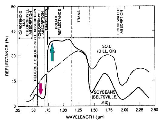
Spectral reflectance signatures of Soybeans and Soil
[Alfredo Huete, et al, 1999]