
We are founded by a group of the University of Twente Alumni offering a tremendous opportunity to understand the fundamental features required for spatial data acquisition and analytics for stakeholders in the agri-food sector to adapt food production to a changing world.
Mission and strategy
AgriWatch is a Dutch consultancy specialized in developing advisory services, practical training and capacity-building programs using Earth Observation and Geo-Information for Agriculture and Water resources management. We cooperate with several universities (e.g., in the Netherlands, Greece, Portugal, Germany, and Poland), specialized companies, and model farmers to increase proficiency in the use of Geospatial data, tools, and services.
AgriWatch is currently leading one Erasmus+ Capacity Building in the field of Vocational Education and Training (CB VET) project (called AgroTec) and participating in one Erasmus+ Knowledge Alliances project and one Horizon 2020 project.
Sector: Geospatial Technology and Agriculture.
Target Groups: governmental sectors, knowledge centres including VET providers and staff/students, research organizations, specialised SMEs, contractors, advisors, and farmers.
The customers: primarily the users of knowledge-based advisory on geodata/services. The content of this knowledge base is updated and maintained in interaction with a group of users.
Goal: to support decision-making by building, measuring and controlling system models (user-specific), of which image analysis is a major part.
Objectives: to generate profit and grow in a responsible and manageable manner. AgriWatch offers consultancy services focusing on the following:
establishing a local network and exchanging good practices for the transfer of knowledge and growing a sustainable community;
the integrated use of digital technologies such as IoT, ICT, and Geospatial technology (hereafter called Geo-ICT);
(timely) Remote Sensing image analysis (Satellite, drones and specialized sensors) on a cost-effective basis;
climate change such as drought and flood;
improving the quality of advisory services.
Mission: to provide useful, reliable, detailed, and up-to-date products for customers using big geodata and knowledge-based services.
Background knowledge: Remote Sensing (RS) and Geographic Information System (GIS) in combination with theory and practice of expert systems/knowledge-based image analysis.
Current business:
providing consultation on building the capacity of VET providers to increase proficiency in the use of Geo-ICT data, tools, and services.
providing advisory services using remote and local sensing data collected for crop conditions and stress monitoring under new climate conditions such as drought. For example, small- to large-scale farmers receive information to optimise fertiliser and irrigation management at the field and farm levels.
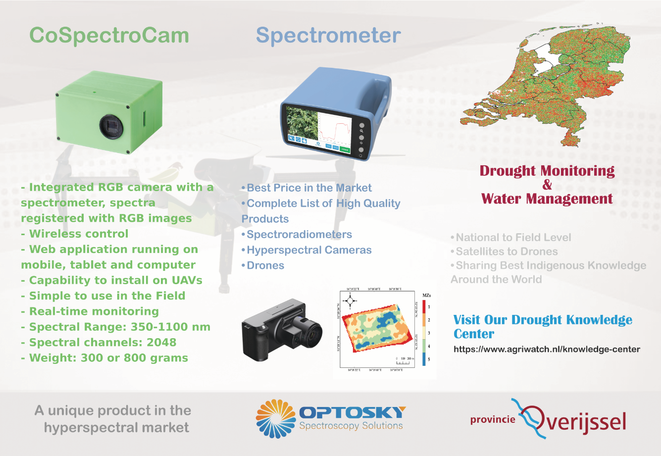
producing the coSpectroCam device for acquiring hyperspectral and RGB data for lab and field measurements.
Current Network: we have an excellent international network and exchange knowledge and experience to support sustainable development. In each consultancy project, special attention will be given to the local network (and local needs) and co-creation solutions with stakeholders (e.g., local SMEs, experts, trainers, and researchers). Linking the regional companies within the network will enhance the sustainability and usability of the solutions.
Contact us for a free personal consultation.
Copyright photo: © ESA/ATG medialab